Platform
The connected workspace for MS4 inspections, tasks, GIS context, and annual reporting.
Inspections, outfalls, BMPs, IDDE, enforcement drafts, and annual-report evidence all live in one workspace — shaped around how a Phase II MS4 program moves through the year.
Overview
What NPDESTracker is, plainly.
A browser-based workspace that holds the records most stormwater teams keep in spreadsheets, PDFs, scanned forms, and shared drives. Inspections, IDDE, sites, outfalls, BMPs, public education, public participation, and the annual report all live in the same system, tied to the permit and the agency you answer to.
Runs in a browser
No installs and no VPN setup. The same workspace opens on a phone in the field and on a laptop at the desk.
Shaped around the permit
Modules track the six Minimum Control Measures, plus the records your state agency asks about in the annual report. Not a generic inspection form.
Built for field use
Inspection forms work on a phone or tablet. Photos and GPS attach to the inspection directly, not to a separate folder somewhere.
Records hold up later
Every entry is timestamped and attributed. When a reviewer asks who saved what and when, the answer is on the record.
01 · Workflows
Core workflows your program runs on.
The everyday motions of an MS4 program, modeled as first-class workflows rather than shoehorned into a generic forms app.
Capture inspections in the field
Mobile-friendly inspection forms with photo and GPS evidence, designed for field use on phones and tablets.
Track sites, outfalls, and BMPs
A living, mapped inventory of every asset your program is responsible for, with inspection history, ownership, and status on each.
Investigate illicit discharges
Complaint, field screening, source tracing, and enforcement, documented in a single traceable thread per incident.
Issue and track enforcement
Notices of violation, compliance schedules, and resolution records with a defensible audit trail from first observation to closure.
Manage public education and outreach
Events, audiences reached, and materials distributed, documented to MCM 1 and MCM 2 requirements as you go.
Assemble annual MS4 reports
Permit-aligned rollups of the full program year, ready to review and submit. No last-minute reformatting.
Coordinate across roles
Field crews, coordinators, and directors see the same underlying data through views tailored to their work.
02 · Field inspections
Inspections that work the way the field actually works.
Inspectors are in trucks, at outfalls behind industrial facilities, on active construction sites, not at a desk. NPDESTracker works in a browser on phones, tablets, and laptops where a connection is available, so the inspection that started in the field can be wrapped up wherever the inspector logs back in.
- Structured, permit-aligned inspection forms, configurable per program and inspection type
- Mobile-friendly inspection forms with photo and GPS evidence, designed for field use on phones and tablets
- GPS-tagged photos attached directly to the record they belong to
- Conditional logic so only the questions that apply to this inspection show up
- Re-inspection scheduling with automatic follow-up flags on deficient findings
- Inspector sign-off with a user-attributed, timestamped record of the completed work
- Runs in any modern browser on phone, tablet, or field-ready device. No native app install required.
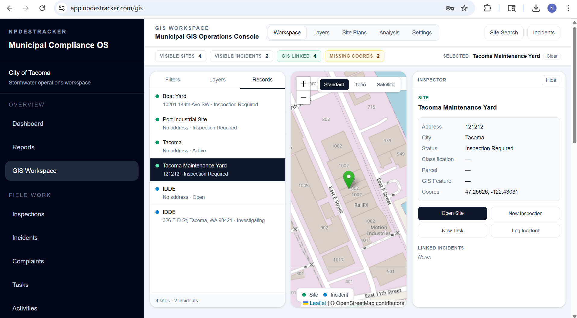
03 · GIS workspace
Stormwater is spatial. Your software should be too.
Every outfall has a location. Every BMP has a parcel. Every complaint has an address. NPDESTracker treats spatial context as a first-class part of the compliance workflow, not a separate GIS product you have to hop into. See how the GIS workspace works, or read about why most municipal programs need both MS4 software and ArcGIS.
04 · Reporting & audit readiness
Annual reporting as a review, not a rebuild.
Every MS4 program knows the pattern: scrambling to assemble the annual report from spreadsheets, emails, and half-remembered events from nine months ago. NPDESTracker flips that. Your annual report is already assembled. It's the live state of your program, rolled up and formatted for your state agency.
- Annual MS4 report structure aligned to state agency expectations
- Live rollups so every inspection, screening, and enforcement action flows in automatically
- Reporting-year scoping that locks prior-year data while you continue to operate in the current year
- CSV exports for supported operational records, with broader export support available during onboarding and support requests
- Audit-ready record history on every compliance item, attributed to the user who entered it
- Year-over-year trend views for program review, council briefings, and grant applications
Detailed product pages: annual reporting, Smart Draft, public education tracking, public participation tracking, MS4 metrics dashboard, and the BMP guide and field reference.
05 · IDDE & investigations
From complaint to closure, in one thread.
Illicit discharge investigations can span days or months. NPDESTracker keeps the whole arc in one traceable record, with every participant, photo, screening result, and action step in sequence. For a working playbook on running an IDDE investigation cleanly, see the complaint-to-closure guide.
Complaint intake
Capture the call the moment it comes in. Address, reporter, classification, and initial photos, all tied to a mapped location from the start.
Field screening
Log dry-weather observations, indicator panel results, and sampling data in the field, with photo evidence attached to the incident.
Source tracing
Work upstream from the outfall. Document each step, suspected source, and evidence collected on the same incident record.
Enforcement linkage
Escalate directly into a notice of violation or compliance order. No re-keying, no separate system. The investigation becomes the evidence.
Closure and documentation
Final status, responsible party, and corrective action recorded for both program and permitting-authority review.
Outfall timeline
Every incident, screening, and inspection on that outfall, ever. One view, always current, always attributable.
06 · Built for your team
Around the people responsible for the permit.
Different roles need different views of the same underlying program data. NPDESTracker meets each person where their work lives.
Stormwater Coordinator
Program-wide status at a glance. Overdue inspections, open IDDE cases, and reporting gaps surface before they become compliance problems.
Field Inspector
Works from a phone or tablet. Mobile-friendly inspection forms with photo and GPS evidence, designed for field use, with no separate app to install.
Public Works Director
Reviews program trends, prepares council briefings, and oversees compliance posture across departments with one live source of truth.
Environmental Compliance Officer
Manages enforcement, tracks notices of violation, and maintains a defensible audit trail from first observation through closure.
Reporting & Grants Staff
Pulls permit-aligned annual reports, exports data for state submittals, and supports grant documentation without rebuilding spreadsheets.
City Engineer
Uses BMP inventory and inspection history to guide capital projects, maintenance priorities, and stormwater system upgrades.
For a topic-by-topic index of the workflow guides, see the stormwater software resources page.
07 · Configurable by your municipality
Built-in modules are the starting point. Configuration is the operating model.
NPDESTracker gives MS4 teams a connected workspace out of the box, then lets admins configure the parts that are local: terminology, forms, fields, dropdowns, displays, custom modules, exports, and mobile field workflows. Built-in modules are the starting point, not the ceiling.
The parts that should be local are handled by the municipality in the workspace. Scoped custom work for agency-specific forms, modules, or reports is available separately.
See configurable stormwater software for the full breakdown, and pricing for what is included with each annual tier.
Included self-service configuration
- Module toggles, so the workspace only shows what your program runs
- Terminology renaming to match local language and the permit
- Configurable fields per inspection kind: which fields show, which are required, and what the labels say
- Dropdown values (BMP types, finding categories, enforcement actions) editable in the workspace
- Custom modules built from the platform's configurable building blocks: record types, fields, dropdowns, and workflows
- Display settings, default views, visible columns, and dashboard widgets configurable per tenant and per role
- Export-ready records in standard formats (CSV, JSON, and GeoJSON where applicable) on every tier
- Mobile-ready field workflows in mobile web today on phones and tablets
Built for real MS4 program variation
Configurable for agency-specific workflows. Scoped setup for larger programs.
Configuration covers module toggles, terminology, dropdowns, and custom modules out of the box. Larger programs often need scoped setup for agency-specific fields, forms, and core-record configuration.
Planning for a larger MS4 program? See how NPDESTracker supports larger-program workflows and scoped implementation planning.
08 · Executive readiness dashboard
Give directors a clear view of MS4 program health.
Inspections, IDDE cases, tasks, evidence links, and program-by-program health roll up into a readiness command center. The dashboard view is what program managers and directors review before the next reporting cycle.
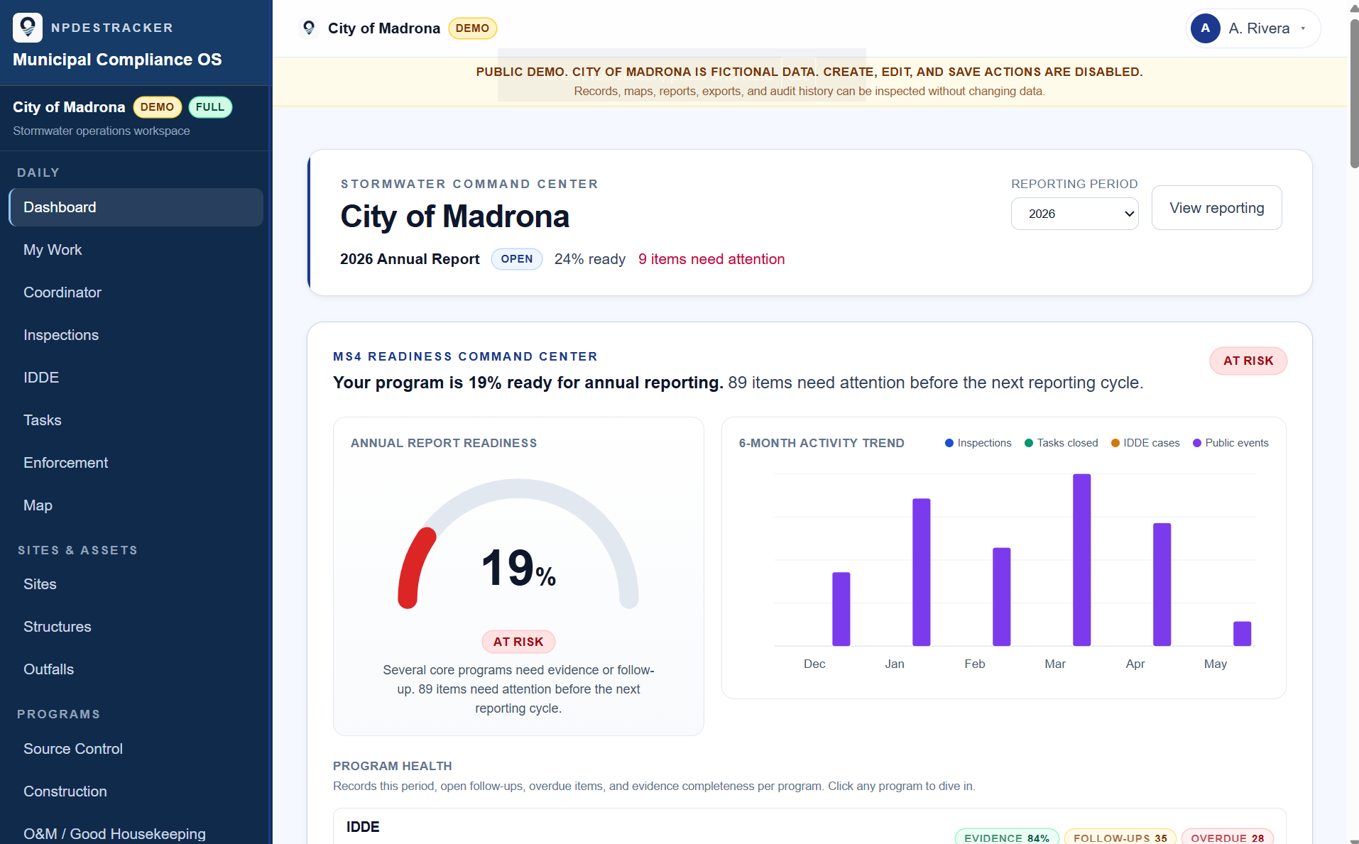
Where the reporting year stands.
Annual report progress at a glance, with the items still open visible per question instead of buried in a spreadsheet.
Six months of the work, in one view.
Inspections logged, tasks closed, IDDE cases opened, and public works activity, charted month by month from the records the team kept.
Status by module, evidence gaps surfaced.
Each MS4 program area carries its own health row so deficiencies surface before they become audit findings.
Fictional demo data. The public demo is read-only. Live tenants configure modules, thresholds, and dashboard widgets per program.
See the platform, with sample data.
Open the interactive demo with sample data. No signup, no call, just browse the real product at your own pace. If it looks like a fit, a 60-day pilot runs it on your own program.