Stormwater field inspection software
Stormwater Field Inspection Software for MS4 Teams.
A mobile-web inspection workflow for field staff. Structured forms per inspection kind, photos and GPS pinned to the record, field markups on a separate exportable layer, draft notices started from the inspection, and tasks for everything that needs follow-up.
01 · Who this is for
For inspectors working the field.
Field inspectors at Phase II MS4 programs spend their day walking sites, opening manhole lids, walking outfalls, and writing it down. NPDESTracker is the place that record lands. Photos, GPS, the form, the follow-up task, and the field markup all land on the same record, the moment the work happens.
Mobile web works today on phones and tablets. A native iOS field app for offline inspections is planned. The 60-day Guided 60-day Evaluation at $999 is a direct way to test the field workflow on your own permit and data. + applicable tax
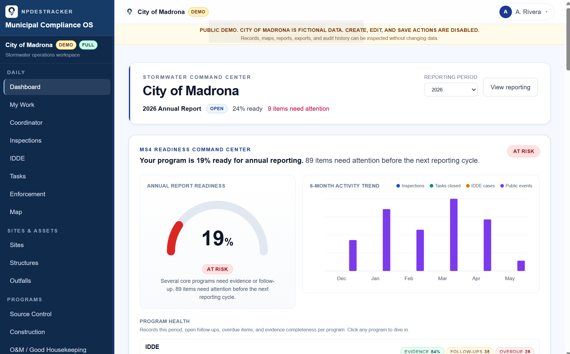
A look at the workspace
See how a sample MS4 workspace connects sites, inspections, tasks, contacts, enforcement drafts, GIS context, and reporting evidence.
02 · Field workflows supported
The kinds of work that happen outside.
The structured form differs by inspection kind. The map, the follow-up tasks, and the field markup layer behave the same regardless. The full inspection workflow is on the inspections page.
Field inspection kinds
- Construction Stormwater inspections during active build-out
- Source Control inspections at industrial and commercial sites
- IDDE field visits, dry-weather screening, and source-tracing
- O&M / Good Housekeeping inspections at municipal facilities
- Post-construction BMP inspections on accepted assets
03 · What inspectors do in the field
Capture once, on the record.
Open the site on a phone or tablet, see the last inspection, fill out the structured form, take photos with GPS attached, draw a missing catch basin or pipe on the field markup layer, and start a draft notice if needed. The follow-up task opens on the same record.
In the inspector's day
- Sites and assets on a map the field staff actually use
- Structured forms per inspection kind on a phone or tablet browser
- Photos and files attached to the inspection from the field
- GPS pinned to the record at the moment of capture
- Tasks for deficiencies, return visits, and cleanup checks
- Field markups drawn in the field as a separate exportable layer
- Draft notice templates from the inspection record
- CSV and GeoJSON exports of field records and evidence
04 · What supervisors see
What field work happened, and what is overdue.
My Work surfaces personal load. Overdue and due-soon field inspections bubble up across the program. Enforcement records link back to the field inspection that triggered them.
What supervisors see
- My Work view that surfaces what each user owns
- Overdue and due-soon field inspections across the program
- Enforcement tracking linked to the inspection that triggered it
- Exportable inspection histories for internal review and recordkeeping
Scope: NPDESTracker does not submit reports to any state agency and does not certify compliance. Optional drafting tools are staff-reviewed. See Terms for the full posture.
06 · FAQ
Frequently asked questions.
Honest answers to the questions that come up most often.
Does the field inspection workflow work on a phone in the field?
Mobile web works today on phones and tablets through any modern browser. A native iOS field app is planned for offline inspection workflows, not launched. Inspectors typically work directly in mobile web and finalize the record when the device reconnects.
How does GPS capture work?
When the inspector captures a photo or saves the inspection in the field, the browser's geolocation pins coordinates to the record. The coordinates land on the inspection itself, not on a separate photo file that drifts from the record over time.
Can field staff draw missing assets like catch basins or pipes?
Yes. Field markups for missing catch basins, pipes, ponds, or field observations are drawn in the field and saved on a separate exportable layer. The markup layer does not write into the authoritative GIS; it exports as GeoJSON for the GIS team to review.
What happens if connectivity drops mid-inspection?
The inspector can keep working in mobile web on a single inspection record. The save action requires connectivity to commit the record to the server. A native iOS app with offline-capable inspection workflows is planned, not launched today.
How does field work tie back to the office side?
The same inspection record is what the office side sees on a desktop. The supervisor's My Work view surfaces overdue and due-soon tasks across the program. Enforcement records link back to the field inspection that triggered them.
Is there a guided evaluation focused on field workflows?
The 60-day Guided 60-day Evaluation at $999 is the most common starting point. It is scoped around inspections, tasks, My Work, field markups, draft notices, enforcement tracking, and exports. Guided setup, email-first support.
Related inspection software pages
The rest of the inspection cluster.
Each page covers a focused slice of the inspection workflow. Pricing is the same across the cluster: the 60-day Guided Evaluation at $999, then Inspection Starter or Inspection Team for the annual tier.
stormwater inspection software
The overview landing page for MS4 inspection teams.
OpenMS4 inspection software
Permit-aligned inspection workflow across MCM 3 through MCM 6.
Opendigital stormwater inspections
Replacing the PDF + folder + spreadsheet stack with one record.
OpenIDDE inspection software
Complaint to closure on one thread per incident.
Opensource control inspection software
Industrial and commercial site inspections with re-inspection cadence.
Openconstruction stormwater inspection software
Active build-out, rainfall-triggered, and BMP findings on one record per visit.
OpenWalk a field inspection on sample data.
Open the demo on a phone or tablet, or email admin@npdestracker.com about a guided evaluation.